|
Historical Information

With a dramatic increase in the volume of maritime traffic making its
way in and out of the twin ports of Duluth and Superior, the
buoyage of the area also saw a sharp increase during the final years of
the nineteenth century. Finding great difficulty in effectively managing
the annual laying-out and retrieving of these buoys and in supplying the
light stations of western Lake Superior from the remote Ninth district
depot in Detroit, the Lighthouse Board began to consider the
establishment of a new buoy depot to serve the area.
 Since the old
Minnesota Point
lighthouse reservation was already Lighthouse Board property and
conveniently located for the area it would serve, the Board first
requested an appropriation of $14,000 for the construction of a depot on
the old Minnesota Point site in its annual report for the 1902 fiscal
year. Congress responded favorably with the requested appropriation on
March 3, 1903. Since the old
Minnesota Point
lighthouse reservation was already Lighthouse Board property and
conveniently located for the area it would serve, the Board first
requested an appropriation of $14,000 for the construction of a depot on
the old Minnesota Point site in its annual report for the 1902 fiscal
year. Congress responded favorably with the requested appropriation on
March 3, 1903.
 Plans and specifications for a buoy
shed, oil house and wharf were drawn up at the district headquarters in
Detroit the following year, and bids were advertised for their
construction. Since no bids were received on the work as a result of
those advertisements, the project had to wait until the 1905, when bids
could be once again be advertised. Plans and specifications for a buoy
shed, oil house and wharf were drawn up at the district headquarters in
Detroit the following year, and bids were advertised for their
construction. Since no bids were received on the work as a result of
those advertisements, the project had to wait until the 1905, when bids
could be once again be advertised.
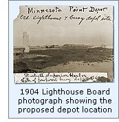
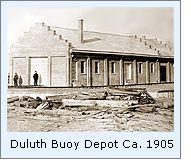
 The site was surveyed and platted in
1904, and the photograph to the upper right was taken at this time to show the proposed
location of the new depot. Even from this early photograph, it can be
seen that the old Minnesota Point Light keeper's dwelling had been
demolished, and that the upper part of the old tower had already begun
to crumble. The site was surveyed and platted in
1904, and the photograph to the upper right was taken at this time to show the proposed
location of the new depot. Even from this early photograph, it can be
seen that the old Minnesota Point Light keeper's dwelling had been
demolished, and that the upper part of the old tower had already begun
to crumble.
 Materials for the construction of the
wharf were delivered, and the work began with the driving of numerous
pilings deep into the lake bottom. Sawed-off at a height three feet
above the lake's surface, the pilings were capped and bridged with thick
planking to support the heavy traffic that the wharf would see. On its
completion in 1906 the wharf stood 196 feet long and 20 feet wide. The
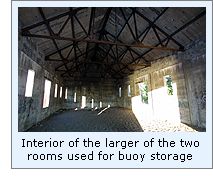
depot was completed with the construction of a concrete structure
containing two distinct areas separated by a fireproof wall. The larger
front Materials for the construction of the
wharf were delivered, and the work began with the driving of numerous
pilings deep into the lake bottom. Sawed-off at a height three feet
above the lake's surface, the pilings were capped and bridged with thick
planking to support the heavy traffic that the wharf would see. On its
completion in 1906 the wharf stood 196 feet long and 20 feet wide. The
depot was completed with the construction of a concrete structure
containing two distinct areas separated by a fireproof wall. The larger
front 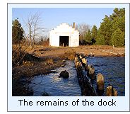 section of the structure was designed for the storage of buoys and
featured large doors at the front and side of the building to allow
large buoys to be moved in and out of the building without obstruction
and a number of windows to allow light to enter the structure. The
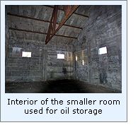
smaller rear storage area was designed for the storage of oil, and
featured but a few few small windows and heavy steel doors to retard the
spread of fire. section of the structure was designed for the storage of buoys and
featured large doors at the front and side of the building to allow
large buoys to be moved in and out of the building without obstruction
and a number of windows to allow light to enter the structure. The
smaller rear storage area was designed for the storage of oil, and
featured but a few few small windows and heavy steel doors to retard the
spread of fire.
As of this writing, we have been unable
to determine when the depot was taken out of service, as we have been
able top find no mention of the depot station in any of the government
reports we have seen after 1910.

Seeing this
depot
We did not have time to go searching for this structure when we were
last in Duluth, and thus did not obtain any photographs. In fact, we assumed
that the building had been demolished since we had never come across any
photographs of the depot in our research. Then on 08/23/01 I received an
email from Duluth resident Colt Edin, who reporting that he had been
boating along the shore of Minnesota Point earlier that week, and saw an
old abandoned concrete structure with USLHS DEPOT cast above its front
door, and came searching our site to see if he could find any
information on the building.
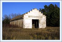
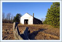
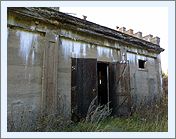
On 11/04/01, I contacted Denis O'Hara
of Northern Images,
who had previously honored us with his photographs of the ruins of the
Minnesota Point Light, to see if he might be willing to photograph the
buoy depot for us. Amazingly, Dennis went out to Minnesota Point the
next day, and sent us the color photographs you see on this page.
A big thank you to both Colt and Dennis
for their kind assistance.
Finding this depot
Hwy
61 slices through Duluth parallel to the lakeshore. From Hwy 61, take
Canal Park Drive into Canal Park drive, and drive across the famous lift
bridge. Continue approximately 3.5 miles to the airport. Park your
vehicle in one of the public parking spaces in the area, and head for a
gated dirt road to the rear of the airport buildings. The road is gated
to prevent vehicle traffic, however foot traffic is welcomed. Continue
approximately 1.5 miles along this trail to the lighthouse ruins. Once
you find the lighthouse ruins you are close to the buoy depot, whish is
located on the St' Louis side of the Point.
Reference
Sources
Annual reports of the Lighthouse Board,
1902 through 1910
08/23/01 email from Colt Edin on the existence of the depot structure.
11/05/01 photographs of the depot by Dennis O'Hara of Northern
Images.
|