|
Historical Information

With the major landmarks and
dangers on the US side of Lake Huron already illuminated, in the final
decades of the nineteenth century the Lighthouse Board turned its
attention to creating a system of coast lights along the lake's western
shore. In creating such a system, the Board planned to strategically
located a series of lighthouses along the coastline in such a way that
mariners would always be within sight of one light of the series.
While the Presque Isle Peninsula had
been lighted since 1840, and the entrance to the Cheboygan River fifty
miles to the north had been lighted since 1851, the New Presque Isle
Light's range of visibility of 19 miles and the Cheboygan Light's
visible range of 13 miles left an unlighted 18 mile intervening stretch
of coastline along which mariners were forced to navigate blind. In it's
annual report for fiscal 1890, the Board recommended that $25,000 be
appropriated for the construction of a new light and fog signal at Forty
Mile Point near Hammond's Bay, at the approximate mid point between the
two lights. Congress appears to have been
unconvinced of the need to create such a system of contiguous coast
lights, as a similar request for the funds to construct the light at
Port Sanilac in 1869 had languished unresolved for 16 years before
Congress finally provided the necessary appropriation in 1885. With this
in mind, it is not surprising that the matter of the Light at Hammond's
Bay remained unresolved until February 15, 1893, when Congress finally
authorized the project, but failed to provide the necessary
appropriation. The Board again requested funding in its 1894 annual
report, with Congress freeing-up the funds as part of the Sundry Civil
Appropriations Act of August 18, 1894.
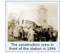 Eleventh District Engineer Major Milton
B. Adams selected and surveyed the site for the new Light. With an offer
of $200 for the property accepted by the owner, Adams approved the plans
and specifications for the station in February 1896. Contracts for the
ironwork for the lantern, gallery, boilers and fog whistles were awarded
soon thereafter, and with receipt of the materials at the Detroit depot,
were loaded aboard the lighthouse tender AMARANTH and delivered to the
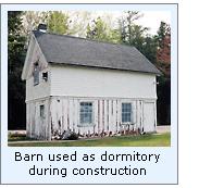
site on July 5, 1896. Work at the site began with the construction of a
wood-framed building, which would be used by the work crew as a
temporary dwelling during construction, and converted into a barn for
the keeper's horses on the completion of the work. Eleventh District Engineer Major Milton
B. Adams selected and surveyed the site for the new Light. With an offer
of $200 for the property accepted by the owner, Adams approved the plans
and specifications for the station in February 1896. Contracts for the
ironwork for the lantern, gallery, boilers and fog whistles were awarded
soon thereafter, and with receipt of the materials at the Detroit depot,
were loaded aboard the lighthouse tender AMARANTH and delivered to the
site on July 5, 1896. Work at the site began with the construction of a
wood-framed building, which would be used by the work crew as a
temporary dwelling during construction, and converted into a barn for
the keeper's horses on the completion of the work.
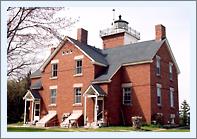
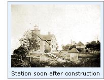
 Adams'
plan for the main lighthouse structure was a virtual duplicate of that
simultaneously under construction at Big Bay Point on Lake Superior.
Consisting of a duplex dwelling with a tower incorporated into the
center of one side-wall, the structure stood 35 feet by 57 feet in plan.
Erected on a 20" thick cut limestone foundation, the brick walls
featured double walls with an air space between to provide insulation.
The integrated tower stood twelve feet in plan, and fifty-two feet in
height. The apartments on each side of the dwelling were exact mirrored
duplicates and were set-up to afford complete privacy. Each apartment
featured its own main entry, cellar, kitchen, parlor, tower entry door
and stairway to the bedrooms on the second floor. Indicative of Adam's
thoughtfulness in designing the structure, each of the stairways
incorporated a skylight in its ceiling through which the lantern could
be observed, thereby allowing both keeper and his assistant to verify
the correct operation of the light from within the warmth of their
apartment without having to leave the building or climb to the top of
the tower itself to see the light. The brick tower was capped by a
square gallery with iron safety railing, and a prefabricated octagonal
cast iron lantern erected at its center. Adams'
plan for the main lighthouse structure was a virtual duplicate of that
simultaneously under construction at Big Bay Point on Lake Superior.
Consisting of a duplex dwelling with a tower incorporated into the
center of one side-wall, the structure stood 35 feet by 57 feet in plan.
Erected on a 20" thick cut limestone foundation, the brick walls
featured double walls with an air space between to provide insulation.
The integrated tower stood twelve feet in plan, and fifty-two feet in
height. The apartments on each side of the dwelling were exact mirrored
duplicates and were set-up to afford complete privacy. Each apartment
featured its own main entry, cellar, kitchen, parlor, tower entry door
and stairway to the bedrooms on the second floor. Indicative of Adam's
thoughtfulness in designing the structure, each of the stairways
incorporated a skylight in its ceiling through which the lantern could
be observed, thereby allowing both keeper and his assistant to verify
the correct operation of the light from within the warmth of their
apartment without having to leave the building or climb to the top of
the tower itself to see the light. The brick tower was capped by a
square gallery with iron safety railing, and a prefabricated octagonal
cast iron lantern erected at its center.
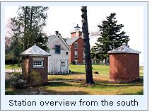
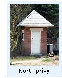 A pair of brick privies were erected to
the rear of the dwelling flanking the barn, and a well was sunk and
equipped with a windmill-operated pump, which discharged water into an
elevated tank to provide a supply of drinking water to the station. The
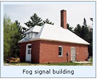
brick fog signal building was erected approximately 290 feet southeast
of the lighthouse. Outfitted with twin boilers installed on raised
concrete pads, the boilers were piped to duplicate 10" steam
whistles located on the lakeside wall and exhausted through a pair of
iron smokestacks. A pair of brick privies were erected to
the rear of the dwelling flanking the barn, and a well was sunk and
equipped with a windmill-operated pump, which discharged water into an
elevated tank to provide a supply of drinking water to the station. The
brick fog signal building was erected approximately 290 feet southeast
of the lighthouse. Outfitted with twin boilers installed on raised
concrete pads, the boilers were piped to duplicate 10" steam
whistles located on the lakeside wall and exhausted through a pair of
iron smokestacks. A 120-foot long T-shaped dock was
erected between the fog signal building and the dwelling, with a
boathouse for the Keeper's boat erected at its shore end. An iron-railed
tramway led from the dock, across post supports to the shore to the fog
signal building and thence behind the dwelling to the barn for the
transportation of coal and supplies delivered by lighthouse tenders
during their semi-annual supply visits. Finally, plank sidewalks were
laid connecting all of the station's structures to provide easy and safe
access to the keepers.
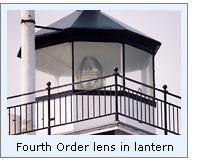 The Eleventh District Lampist arrived
from Detroit, and carefully assembled the Fourth Order Fresnel lens atop
a cast iron pedestal within the lantern. Designed and manufactured by
Henry-Lepaute in Paris, the lens was equipped with six
bulls-eye flash panels. Powered by a clockwork mechanism, the lens was
designed to be rotated around the lamp at a carefully regulated speed in
order to emit the station's specified characteristic white flash every
ten seconds. The Eleventh District Lampist arrived
from Detroit, and carefully assembled the Fourth Order Fresnel lens atop
a cast iron pedestal within the lantern. Designed and manufactured by
Henry-Lepaute in Paris, the lens was equipped with six
bulls-eye flash panels. Powered by a clockwork mechanism, the lens was
designed to be rotated around the lamp at a carefully regulated speed in
order to emit the station's specified characteristic white flash every
ten seconds.
 With construction completed on November
12, 1896 and winter setting in, it was deemed too late in the year to
activate the Light. Thus, a caretaker was hired to live in and watch
over the building until the appointment of a Keeper and Assistant at the
opening of the following navigation season. Xavier Rains, who had been
served for a year as Keeper of the Round Island Light in the St. Mary's
River was selected as Keeper, and Edward Lane was promoted from his
position as Second Assistant at Devils Island to Assistant at Forty Mile
Point. Both Rains and Lane first appear on payroll records at Forty Mile
Point on January 4, 1897. It is therefore likely that they arrived at
the station on this date, and after preparing the station for operation,
exhibited the Forty Mile Point Light for the first time on the night of
May 1, 1897. With construction completed on November
12, 1896 and winter setting in, it was deemed too late in the year to
activate the Light. Thus, a caretaker was hired to live in and watch
over the building until the appointment of a Keeper and Assistant at the
opening of the following navigation season. Xavier Rains, who had been
served for a year as Keeper of the Round Island Light in the St. Mary's
River was selected as Keeper, and Edward Lane was promoted from his
position as Second Assistant at Devils Island to Assistant at Forty Mile
Point. Both Rains and Lane first appear on payroll records at Forty Mile
Point on January 4, 1897. It is therefore likely that they arrived at
the station on this date, and after preparing the station for operation,
exhibited the Forty Mile Point Light for the first time on the night of
May 1, 1897.
 Within a year, problems were
experienced with the drinking water supply, and a work crew arrived at
the station to construct a new foundation, elevated support frame for
the water tank, and completely replaced the water supply piping leading
into the dwelling. In November 1900, the posts supporting the tramway
from the dock to the shore were found to have deteriorated
significantly, and were replaced by five substantial timber cribs filled
with stone, and a log retaining wall was built along the sand bank
behind the boathouse to stem erosion. Within a year, problems were
experienced with the drinking water supply, and a work crew arrived at
the station to construct a new foundation, elevated support frame for
the water tank, and completely replaced the water supply piping leading
into the dwelling. In November 1900, the posts supporting the tramway
from the dock to the shore were found to have deteriorated
significantly, and were replaced by five substantial timber cribs filled
with stone, and a log retaining wall was built along the sand bank
behind the boathouse to stem erosion. 1901 saw the busiest year at the
Forty-Mile Point fog signal station, with the whistles kept operating
for a total of 274 hours, and consuming 7 tons of coal. By 1905, the
twin iron smokestacks on the fog signal building were so badly rusted
and decayed that they were replaced by a single, three-foot square brick
chimney into which both boilers were exhausted.
 On
October 19, 1905, the Lake was assaulted by fierce storms, and twenty
seven wooden ships went down, with an accompanying loss of fifty lives.
The wooden hulled steamer JOSEPH S. FAY was Southbound, towing the
schooner barge D. P. RHODES, when the storm caused the RHODES to break
free, dragging with her a portion of the FAY's stern. Finding his vessel
to be sinking, the Captain of the FAY turned toward shore, only to catch
her bow on a sandbar, swinging her around into the oncoming sea, ripping
off the forward cabin. The Captain and ten crewmen were carried to shore
safely within the cabin. Two crewmen made it to shore alive, but the
First Mate was not so fortunate, His body was found on the beach about a
mile to the north almost two months later. On
October 19, 1905, the Lake was assaulted by fierce storms, and twenty
seven wooden ships went down, with an accompanying loss of fifty lives.
The wooden hulled steamer JOSEPH S. FAY was Southbound, towing the
schooner barge D. P. RHODES, when the storm caused the RHODES to break
free, dragging with her a portion of the FAY's stern. Finding his vessel
to be sinking, the Captain of the FAY turned toward shore, only to catch
her bow on a sandbar, swinging her around into the oncoming sea, ripping
off the forward cabin. The Captain and ten crewmen were carried to shore
safely within the cabin. Two crewmen made it to shore alive, but the
First Mate was not so fortunate, His body was found on the beach about a
mile to the north almost two months later. Four years after assuming
responsibility for the nation's aids to navigation, Commissioner of
Lighthouses Charles R Putnam made the startling revelation that the
Forty Mile Point Light had been built in the wrong location. In his 1913
annual report to Congress, he stated that the county survey charts used
in selecting the site in 1896 were in error, and that vessel masters
expected the lighthouse to be erected at Nine Mile Point, some 20 miles
to the northeast, where a total of nine strandings had occurred between
1903 and 1909. With Eleventh District Inspector E L Woodruff's 's
estimate that a new Light and fog signal could be built at Nine Mile
Point for $50,000, Putnam suggested that with the appropriation, the
Forty Mile Point Light could be downgraded, and the fog signal
eliminated. After Putnam reiterated the request for the appropriation in
his 1914 annual report, Congress responded turned down the request, and
Putnam forever abandoned the cause.
 That same year, on July 10, 1914, the
illuminating apparatus at Forty Mile Point was upgraded to an
incandescent oil vapor (I.O.V) system with an increase in intensity to
55,000 candlepower and a resulting increase in the Light's visible range
to 16 miles. That same year, on July 10, 1914, the
illuminating apparatus at Forty Mile Point was upgraded to an
incandescent oil vapor (I.O.V) system with an increase in intensity to
55,000 candlepower and a resulting increase in the Light's visible range
to 16 miles. 1931 saw the removal of the steam
whistles from the fog signal building and the installation of a pair of
Type F diaphones, representing a significant improvement in both the
audible range and speed at which the signals could be activated. The station was automated in 1969, and
is now part of a county park and one half of the dwelling has been
turned into a museum, and the other half as quarters for the caretaker.
The tower has been opened to the public, and visitors can climb the
stairs to view the Fourth Order lens close up and enjoy the view across
Lake Huron.

Keepers of
this Light
Click here
to see a complete listing of all Forty Mile Point Light keepers compiled
by Phyllis L. Tag of Great Lakes Lighthouse Research.
Seeing this Light
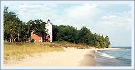
Go North from Rogers City on US23 approximately 6 miles to the entrance
to the Presque Isle County Lighthouse Park. The entrance is on the East
side of the road, and is signed. Drive down the narrow tree-lined
entrance to the park to the Lake. There is a parking area behind the old
fog signal building, and the lighthouse is to the North. Also walk to
the beach and continue North a few hundred yards to see the remains of
the wooden hulled steamer Joseph S. Fay.
The lighthouse is operated by the 40 Mile Point Lighthouse
Society. For open hours and information, visit their website at
www.40milepointlighthouse.org
The Society may also be reached at:
40 Mile Point Lighthouse
Society
PO Box 205
Rogers City, MI 49779
Reference Sources
Annual reports of the Lighthouse
Board, various, 1890 - 1909
Annual reports of the Lighthouse Service, 1910-1920
Annual report of the Lake Carrier's Association, 1913
Inventory of Historic
Light Stations, NPS, 1994
Northern Lights, Charles K. Hyde, 1995
USCG Historian's Office -
photographic archives.
Personal observation at Forty Mile Point, 09/11/1998
Photographs from the author's personal collection.
Keeper listings for this light appear courtesy of Tom & Phyllis Tag
|