 |
 |
 |
|
| Click thumbnails to view enlarged versions | |||
| Grand Island Rear Range light | Seeing The Light |
|
|
|
|
Historical Information The
expanse of Grand Island lies a short distance off the south shore of
Lake Superior, offering a large sheltered area on its lee side. Vessels
had long used the security of this natural harbor of refuge to escape
the fury of Superior's storms, and with the opening of the locks at
Sault Ste. Marie in 1855, maritime commerce on Lake Superior
skyrocketed, and the importance of this natural harbor of refuge grew
proportionately. With both east and west channels leading into the
harbor, the way was safe enough during daylight hours, however
threading the needle between the island and the mainland under the inky
blackness of Superior night was treacherous at best. 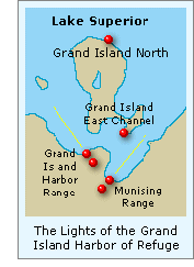 The
Lighthouse Board originally proposed the establishment of lights to
mark these two harbor channels in its annual report for 1865, with
congress responded with an appropriation of ten thousand dollars for
construction of the lights on July 28, 1866. However, after
consultation with maritime interests, the Board determined that range
lights would better suit the needs of mariners entering the western
passage. The district Engineer selected three parcels totaling
115 acres as the site for the ranges and clear title to the parcels
obtained late that year. The
Lighthouse Board originally proposed the establishment of lights to
mark these two harbor channels in its annual report for 1865, with
congress responded with an appropriation of ten thousand dollars for
construction of the lights on July 28, 1866. However, after
consultation with maritime interests, the Board determined that range
lights would better suit the needs of mariners entering the western
passage. The district Engineer selected three parcels totaling
115 acres as the site for the ranges and clear title to the parcels
obtained late that year.It was the original plan to build the new station in the spring of 1867 using the same construction crew that was building a new station at Gull Rock off the Keweenaw Peninsula. However, work at Gull Rock was delayed when the foremen in charge of the project sadly drowned, and as a result construction of the Grand Island Range would not begin until 1868. 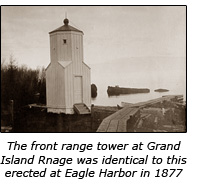 The
front light took the form of a square timber frame structure standing
eight feet in plan which rose to form an octagonal tower. Since only a
narrow arc of visibility was necessary in this application, the light
was exhibited from a small 22” by 29” window in the tower, with the
illumination provided by a steamer lens outfitted with a Franklin lamp
creating a luminosity equivalent to a Sixth Order Fresnel lens. A small
window in the rear of the tower allowed the keeper to monitor the light
from his home in the rear range structure. Standing 24 feet from its
concrete foundation to the vent ball, the light stood at a focal plane
of 23 feet and was visible for a distance of ten nautical miles in
clear weather conditions. Unfortunately, we have yet to locate any
historic photographs of this structure, but from descriptions contained
in Lighthouse Board survey reports, it is evident that it was virtually
identical to structures erected between throughout the district,
similar to the photograph to the left above. The
front light took the form of a square timber frame structure standing
eight feet in plan which rose to form an octagonal tower. Since only a
narrow arc of visibility was necessary in this application, the light
was exhibited from a small 22” by 29” window in the tower, with the
illumination provided by a steamer lens outfitted with a Franklin lamp
creating a luminosity equivalent to a Sixth Order Fresnel lens. A small
window in the rear of the tower allowed the keeper to monitor the light
from his home in the rear range structure. Standing 24 feet from its
concrete foundation to the vent ball, the light stood at a focal plane
of 23 feet and was visible for a distance of ten nautical miles in
clear weather conditions. Unfortunately, we have yet to locate any
historic photographs of this structure, but from descriptions contained
in Lighthouse Board survey reports, it is evident that it was virtually
identical to structures erected between throughout the district,
similar to the photograph to the left above.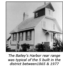 Between
1865 and 1877 five identical rear range structures were
established around the Eleventh lighthouse district at Copper
Harbor, Eagle Harbor, Baileys Harbor, Presque Isle and the
Portage River. In all cases but here at the Grand Island
Harbor Range, the rear range structure consisted of a small timber
frame keepers dwelling with a small lantern atop its roof, of which
this photo of the Baileys Harbor rear range structure is typical. Between
1865 and 1877 five identical rear range structures were
established around the Eleventh lighthouse district at Copper
Harbor, Eagle Harbor, Baileys Harbor, Presque Isle and the
Portage River. In all cases but here at the Grand Island
Harbor Range, the rear range structure consisted of a small timber
frame keepers dwelling with a small lantern atop its roof, of which
this photo of the Baileys Harbor rear range structure is typical. 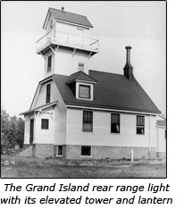 Because
of the lay of the land, the rear range light at the Grand Island Harbor
Range needed to be taller than those at any of its sister stations, and
rather than design a new structure from scratch, the existing plan was
modified to include a taller tower and gallery. The second floor of the
dwelling was also modified with dormers to provide additional living
space within the roof. These modifications combined to create a
noticeably more substantial structure, as shown in the accompanying
historic photograph. Because
of the lay of the land, the rear range light at the Grand Island Harbor
Range needed to be taller than those at any of its sister stations, and
rather than design a new structure from scratch, the existing plan was
modified to include a taller tower and gallery. The second floor of the
dwelling was also modified with dormers to provide additional living
space within the roof. These modifications combined to create a
noticeably more substantial structure, as shown in the accompanying
historic photograph. With its vent ball located 37 feet above its brick foundation, the rear range was outfitted with the same glass tubular flap lens with a Franklin lamp as the front range. However, with its optic situated at a higher 45 foot focal plane, its light was visible for a distance of 12 ½ miles. Frederick Giertz, a neophyte to lighthouse service, was appointed as the station’s first keeper, and officially exhibited the stations lights for the first time on the night of August 21, 1868. Evidently, Giertz was ill-suited for lighthouse keeping as he was removed from the position on September 13, 1869 to be replaced by the newly hired Samuel L Barney. Over the years, a total of six keepers would make their homes in the range dwelling their home, with the average tenure of five of them being only a little over 4 years. One notable exception was found in Casper Kuhn who was appointed as keeper of the ranges on July 19, 1876 and remained in charge of the range lights for nineteen years until he passed away at the home he had purchased in Marquette on March 16, 1895. At the time of his death, Kuhn was a veteran of 33 years of lighthouse service, having started in the engineering department as a construction worker before successfully applying for the position of assistant keeper at Au Sable Point lighthouse in 1874. It is evident that Kuhn did well in that position, as he was promoted to the position of principal keeper after only two years. With Au Sable Point being such a remote station, Kuhn likely jumped at the opportunity to transfer to the Grand Island range light station. Kuhn was well liked and respected by his fellow Lake Superior keepers, with six keepers from Marquette and Stannard Rock light station serving as pall bearers at his funeral in Marquette.  By
1914, the original timber frame front and rear range structures had
deteriorated to a point that they needed complete replacement. With
advancements in acetylene technology and the Sun Valve which allowed a
light to be automatically controlled by the light f day, the decision
was made to automate the station and replace both towers with more
durable structures requiring less maintenance. To this end a work
party arrived at the station in 1913 and set about the work of
demolishing and replacing the aging structures. By
1914, the original timber frame front and rear range structures had
deteriorated to a point that they needed complete replacement. With
advancements in acetylene technology and the Sun Valve which allowed a
light to be automatically controlled by the light f day, the decision
was made to automate the station and replace both towers with more
durable structures requiring less maintenance. To this end a work
party arrived at the station in 1913 and set about the work of
demolishing and replacing the aging structures.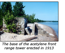 To
support the new front range structure, the construction crew poured a
concrete foundation some five feet in height with six steps leading to
its upper level on the lakeward side. Atop this foundation, the
structure took the form of a 23 foot tall square iron mast equipped
with a slatted white daymark and a small acetylene gas storage building
alongside the concrete base. The acetylene burner was housed in a 350
mm pressed glass lens with an output of 3,600 candlepower. Equipped
with a flashing mechanism to provide a short 0.3 second flash every
second to conserve acetylene, its light was visible for 11 miles. To
support the new front range structure, the construction crew poured a
concrete foundation some five feet in height with six steps leading to
its upper level on the lakeward side. Atop this foundation, the
structure took the form of a 23 foot tall square iron mast equipped
with a slatted white daymark and a small acetylene gas storage building
alongside the concrete base. The acetylene burner was housed in a 350
mm pressed glass lens with an output of 3,600 candlepower. Equipped
with a flashing mechanism to provide a short 0.3 second flash every
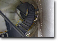
second to conserve acetylene, its light was visible for 11 miles.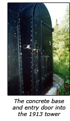 The
new rear range structure took the form of a conical cast iron tower
standing 64 feet tall, with its upper 32 feet consisting of a tower
that had previously seen service at another location which has yet to
be determined. To elevate this tower, a riveted steel base fabricated
of 1/2-inch thick steel plates over vertical 4" x 4" steel channels was
erected on a new concrete foundation and the relocated tower lifted and
bolted atop this new base. Also equipped with a 350 mm pressed glass
lens, the acetylene flasher in the rear tower was adjusted to provide
an isophase characteristic of a single flash of one second duration
followed by a one second eclipse. With a focal plane of 72 feet, its
light was now visible at a distance of 16 miles in clear conditions. The
new rear range structure took the form of a conical cast iron tower
standing 64 feet tall, with its upper 32 feet consisting of a tower
that had previously seen service at another location which has yet to
be determined. To elevate this tower, a riveted steel base fabricated
of 1/2-inch thick steel plates over vertical 4" x 4" steel channels was
erected on a new concrete foundation and the relocated tower lifted and
bolted atop this new base. Also equipped with a 350 mm pressed glass
lens, the acetylene flasher in the rear tower was adjusted to provide
an isophase characteristic of a single flash of one second duration
followed by a one second eclipse. With a focal plane of 72 feet, its
light was now visible at a distance of 16 miles in clear conditions.Rather than demolishing the old timber-framed Grand Island Harbor rear range structure, the decision was made to offer the building for sale, with the stipulation that it be removed from the property. The old lighthouse was thus sold, its tower and lantern removed and the entire building moved approximately 3 ½ miles to downtown Munising, where it was placed on a new foundation and modified to serve as a private dwelling. 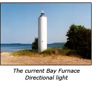 With
changing commercial maritime traffic patterns , it was determined in
that the Grand Island Harbor Range was no longer a necessary aid to
navigation, and the light in the rear range tower was extinguished in
1969, and the skeletal iron front range light left to serve alone under
the new name of the “Bay Furnace Directional light." With
changing commercial maritime traffic patterns , it was determined in
that the Grand Island Harbor Range was no longer a necessary aid to
navigation, and the light in the rear range tower was extinguished in
1969, and the skeletal iron front range light left to serve alone under
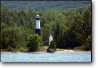
the new name of the “Bay Furnace Directional light." Showing significant signs of deterioration, this structure too was cut from its concrete base in the mid 1980's, and replaced with an ignominious “D9” cylindrical tower approximately 35 feet to the south. This type of tower is unique to the Great Lakes, and takes its name from the Ninth Coast Guard District which was responsible for its design, with similar structures in use throughout the Great Lakes. 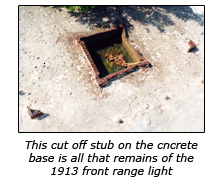 While
the old acetylene front range tower was removed and scrapped, its
concrete foundation and steps still stand at the water’s edge to the
north of the D9 tower, the severed stubs of the old structure still
protruding from its upper surface. While
the old acetylene front range tower was removed and scrapped, its
concrete foundation and steps still stand at the water’s edge to the
north of the D9 tower, the severed stubs of the old structure still
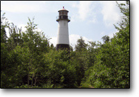
protruding from its upper surface. The old steel and iron rear range structure erected in 1913 still stands approximately 235 feet to the south of highway 28 in the woods west of Munising, and 730 feet south of 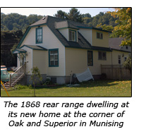 the still active Bay Furnace Directional Light. The old tower was transferred to the Hiawatha National Forest via the National
Historic Lighthouse Preservation Act. While its lantern glass has all
been removed, it is still in fairly good condition. While some sources
refer to this old tower as the “Christmas Light,” the “End of the road
rear Range” and the “Bay Furnace Rear Range Light,” they are
incorrect, as it should correctly be known as the rear tower of the
long defunct Grand Island Harbor Range. the still active Bay Furnace Directional Light. The old tower was transferred to the Hiawatha National Forest via the National
Historic Lighthouse Preservation Act. While its lantern glass has all
been removed, it is still in fairly good condition. While some sources
refer to this old tower as the “Christmas Light,” the “End of the road
rear Range” and the “Bay Furnace Rear Range Light,” they are
incorrect, as it should correctly be known as the rear tower of the
long defunct Grand Island Harbor Range.The 1868 rear range structure still serves as a private home at the corner of West Superior and Oak Street in Munising. While its heritage is likely unknown to most people who pass it by, its proud heritage is still recognizable to those who know its story.
Click here
to see a complete listing of all Grand Island Harbor Range Light keepers
compiled by Phyllis L. Tag of Great Lakes Lighthouse Research.
The 1913 Rear Range tower is located at the end of a 236 foot gravel drive to the south of Highway 28, and is very easy to miss when driving at speed in either direction. From the west, this drive is located apprximately 0.6 miles east of the entrance to the Bay Furnace park, and from the east, it is approximately 1.6 miles west of the Holiday Inn Express hotel on the outskirts of Munising. There is room to park on eather side of Hwy 28 near the gravel drive. A short 500 foot walk down a sandy drive to the north of Hwy 28 will lead you to the active Bay Furnace Directional light and the foundation of the acetylene tower nearby at the water's edge.
GPS Coordinates |