|
Historical Information

Just offshore, a narrow ten-mile long sand bar stretches between the
twin ports of Duluth and Superior. Reputedly the longest freshwater sand
bar in the world, the bar is split by a natural opening in its'
approximate center. Appropriately, the bar on the Minnesota side of the
opening is known as Minnesota Point, and the bar on the Wisconsin side
is known as Wisconsin Point.
As the twin ports of Duluth and Superior began to grow in their
importance as ports, the quantity of vessel traffic making its way
through this opening began to increase. In order to make passage safer,
in 1856 the Lighthouse Board constructed a stone tower and keepers
dwelling at the end of Minnesota Point for a total cost of $13,700.
After the channel was cut through Minnesota Point at the Duluth
end in 1872 and the Duluth
South Breakwater Light was established to mark the the new entry,
maritime traffic bound for Duluth no longer needed to enter the harbor
through the circuitous gap, and thus the opening began to be used solely
for Superior traffic.
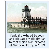 With the construction of protective timber piers at each side of the
entry, a wood-framed pierhead beacon was erected on the end of the north
pier in 1879, and exhibited for the first time on the night of September
1 of that year. With the Army Corps of Engineers continuing to dredge
and enlarge the opening, the pierhead light was temporarily discontinued
in 1880, and the old Minnesota Point light reactivated until work on the
improved piers had progressed to a point that the pierhead beacon could
be reestablished. This work was completed in 1885, and the pierhead
beacon reestablished on the North Pierhead. With the establishment of
this beacon, the old Minnesota Point Light was deactivated, and the
dwelling refurbished to serve as quarters for the Keeper of the new
light. With the construction of protective timber piers at each side of the
entry, a wood-framed pierhead beacon was erected on the end of the north
pier in 1879, and exhibited for the first time on the night of September
1 of that year. With the Army Corps of Engineers continuing to dredge
and enlarge the opening, the pierhead light was temporarily discontinued
in 1880, and the old Minnesota Point light reactivated until work on the
improved piers had progressed to a point that the pierhead beacon could
be reestablished. This work was completed in 1885, and the pierhead
beacon reestablished on the North Pierhead. With the establishment of
this beacon, the old Minnesota Point Light was deactivated, and the
dwelling refurbished to serve as quarters for the Keeper of the new
light.
With the Army Engineer’s continuing to work on the piers, the
decision was made to relocate the beacon across the channel to the
longer south pier in 1892. After the beacon was transported across the
channel and bolted in its new home, an elevated walk was erected from
the beacon leading toward the shore to provide the Keeper with safe
access to the light during stormy weather when waves washed across the
surface of the pier. With the old Minnesota Point dwelling now
inconveniently located on the opposite side of the channel, cost
estimates and plans were also drawn up for the erection of a duplex
keepers dwelling on the Wisconsin side of the entry. Also this year, the
Lighthouse Board recommended the establishment of a fog signal on the
south pier to serve as a guide to vessels making the entry at night and
during thick weather, and requested an appropriation of $5,500 for its
establishment.
1883 saw major changes at Superior entry with the arrival of a work
crew at the site at the opening of the navigation season. Over the
summer, the duplex dwelling with a six-room apartment on each side was
built, and after erection of a boathouse, barn and 360-gallon capacity
brick oil storage building, the buildings were connected with walkways
and the station enclosed by a 200-foot by 200-foot picket fence.
That summer, work began on construction of a 20-foot by 40-foot steam
fog signal building behind the beacon at the end of the south pier. A
timber frame structure, its exterior walls were covered with corrugated
iron sheets, and the inner walls with smooth iron sheeting. Within the
building, a pair of locomotive-style steam boilers were installed and
plumbed into a pair of 6-inch Scotch whistles, which were mounted on the
iron roof of the structure. After the elevated walkway was connected to
the fog signal building and extended an additional 100 feet toward the
shore, work on the fog signal was completed and the signal placed in
operation on August 27, 1893. It would appear that the new fog signal
was indeed a valuable enhancement to navigation, as two years after its
establishment, the keepers toiled to feed 44 tons of coal into the
hungry boilers to keep the whistles screaming their warning across
Superior for a station record 895 hours.
In 1898, the decision was made to add a second light on the south
pier to serve as a rear range to the pierhead beacon to help mariners
locate the course into the channel. With work underway at the Devils
Island light station to replace the temporary timber-framed beacon on
the island with a permanent iron structure, plans were put in place to
move the old beacon to Superior Entry to serve as the new rear beacon.
However, with the lens for the new Devils Island tower unavailable, and
delaying the availability of that structure, a temporary post was
erected on the south pier 1,650 feet behind the pierhead light, and
exhibited for the first time on the night of November 30, 1897.
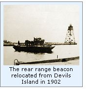 With the installation of the lens in the iron tower on Devils Island
late in the summer of 1901, the old timber beacon was removed from the
island and shipped to Superior. On erection on the south pier, the
lantern was outfitted with a fixed white Fourth Order Fresnel
lens. With
the work completed close to the end of the navigation season, the new
rear range light was not exhibited from the relocated structure until
the opening of the 1902 navigation season on April 1, 1902. With the installation of the lens in the iron tower on Devils Island
late in the summer of 1901, the old timber beacon was removed from the
island and shipped to Superior. On erection on the south pier, the
lantern was outfitted with a fixed white Fourth Order Fresnel
lens. With
the work completed close to the end of the navigation season, the new
rear range light was not exhibited from the relocated structure until
the opening of the 1902 navigation season on April 1, 1902.
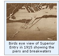 The Army Corps of Engineers were back at work at Superior Entry in
1905, erecting new concrete piers to the outside of the old timber
structures. With plans to remove the old piers on their completion, it
was clear that the existing front range on the pierhead, fog signal and
rear range would need to be relocated to the new concrete piers on their
completion. Estimating the cost of erecting new structures on the
concrete piers to be $20,000, the Lighthouse Board requested an
appropriation of that amount in its annual report for 1905, and began
working on plans and specifications for the new structures. As is all
too frequently the case, the greatest of man’s plans stood like twigs
in the face of Mother Nature’s fury when a violent storm swept across
Lake Superior on November 27. By the time the storm had abated the
following day, the Superior Entry Keepers were faced with an incredible
scene of devastation. Waves smashing across the pier had snapped the
12-inch timbers of the front beacon like matchsticks, completely
carrying the structure away, along with 250 feet of the elevated walk.
The roof and upper two thirds of the fog signal building were completely
gone, along with 40 tons of coal which had been swept from the hopper.
Repair work began immediately with the temporary rebuilding of the fog
signal building, and the erection of a temporary frame lantern installed
atop the structure’s roof. However, with winter putting an end to the
work, the fog signal and light were not reactivated until April 15 of
the following year. The Army Corps of Engineers were back at work at Superior Entry in
1905, erecting new concrete piers to the outside of the old timber
structures. With plans to remove the old piers on their completion, it
was clear that the existing front range on the pierhead, fog signal and
rear range would need to be relocated to the new concrete piers on their
completion. Estimating the cost of erecting new structures on the
concrete piers to be $20,000, the Lighthouse Board requested an
appropriation of that amount in its annual report for 1905, and began
working on plans and specifications for the new structures. As is all
too frequently the case, the greatest of man’s plans stood like twigs
in the face of Mother Nature’s fury when a violent storm swept across
Lake Superior on November 27. By the time the storm had abated the
following day, the Superior Entry Keepers were faced with an incredible
scene of devastation. Waves smashing across the pier had snapped the
12-inch timbers of the front beacon like matchsticks, completely
carrying the structure away, along with 250 feet of the elevated walk.
The roof and upper two thirds of the fog signal building were completely
gone, along with 40 tons of coal which had been swept from the hopper.
Repair work began immediately with the temporary rebuilding of the fog
signal building, and the erection of a temporary frame lantern installed
atop the structure’s roof. However, with winter putting an end to the
work, the fog signal and light were not reactivated until April 15 of
the following year.
 Congress responded to the previous year’s request with an
appropriation of $20,000 on June 30, 1906, however with the Army Corps
of Engineers still working on the new concrete piers, the construction
was postponed pending the completion of the new structures. By 1910, the
Corps of Engineers had revised their plans for Superior Entry, deciding
to construct two long concrete arrowhead breakwaters outside of the
piers in order to create a large stilling basin. With these
enhancements, the newly formed Lighthouse Establishment was forced to
rethink its plan for lighting the harbor entry. Determining that it
would be best to erect the fog signal and main entry light at the end of
the South Breakwater and to establish unmanned acetylene beacons on the
piers, it estimated that the total cost of construction would now reach
$45,000, which was $25,000 beyond the Congressional appropriation of
1906, and requested a second appropriation of $25,000. Congress
responded with the requested secondary appropriation on March 4, 1911,
and preliminary plans for the structures were drawn up and approved soon
thereafter, and by July, the Army Corps of Engineers had completed work
on the 11 ½ foot high concrete base for the new South Breakwater
Pierhead light. Contracts for construction were awarded on June 30,
1912, and construction began almost immediately. Congress responded to the previous year’s request with an
appropriation of $20,000 on June 30, 1906, however with the Army Corps
of Engineers still working on the new concrete piers, the construction
was postponed pending the completion of the new structures. By 1910, the
Corps of Engineers had revised their plans for Superior Entry, deciding
to construct two long concrete arrowhead breakwaters outside of the
piers in order to create a large stilling basin. With these
enhancements, the newly formed Lighthouse Establishment was forced to
rethink its plan for lighting the harbor entry. Determining that it
would be best to erect the fog signal and main entry light at the end of
the South Breakwater and to establish unmanned acetylene beacons on the
piers, it estimated that the total cost of construction would now reach
$45,000, which was $25,000 beyond the Congressional appropriation of
1906, and requested a second appropriation of $25,000. Congress
responded with the requested secondary appropriation on March 4, 1911,
and preliminary plans for the structures were drawn up and approved soon
thereafter, and by July, the Army Corps of Engineers had completed work
on the 11 ½ foot high concrete base for the new South Breakwater
Pierhead light. Contracts for construction were awarded on June 30,
1912, and construction began almost immediately.
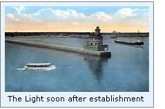
 The concrete foundation for the Main Light and fog signal contained
vaulted cellar rooms for the storage of oil and paint, along with a
large tank for drinking water. Atop this foundation, the main structure
took the shape of an oblong two-story reinforced concrete building with
rounded ends. Structural steel framing within the building carried
concrete floors, and all interior walls were lined with plaster-finished
terra cotta tile. Inner partition walls were of expanded metal with a
smooth coating of plaster, and the stairs between the decks of cast
iron. The first deck served as a mechanical room, housing a pair of
compressors powered by 22-horsepower inline gasoline engines to supply
air to the fog signal, a steam heating plant, toilet and cold storage
areas. The second floor made up the living quarters, with a kitchen,
living room, three bedrooms and a bathroom. The circular tower rose
through the sheet metal roof at the offshore end of the building, with a
spiral stairway leading from The concrete foundation for the Main Light and fog signal contained
vaulted cellar rooms for the storage of oil and paint, along with a
large tank for drinking water. Atop this foundation, the main structure
took the shape of an oblong two-story reinforced concrete building with
rounded ends. Structural steel framing within the building carried
concrete floors, and all interior walls were lined with plaster-finished
terra cotta tile. Inner partition walls were of expanded metal with a
smooth coating of plaster, and the stairs between the decks of cast
iron. The first deck served as a mechanical room, housing a pair of
compressors powered by 22-horsepower inline gasoline engines to supply
air to the fog signal, a steam heating plant, toilet and cold storage
areas. The second floor made up the living quarters, with a kitchen,
living room, three bedrooms and a bathroom. The circular tower rose
through the sheet metal roof at the offshore end of the building, with a
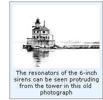
spiral stairway leading from 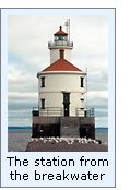 the second floor. The circular tower
protruded from the offshore end of the building, and featured two
floors, the lowest of which housed a pair of six-inch air sirens with
their resonators protruding out the wall, and the second serving as a
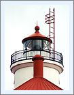
service room. Atop the service room, a copper-roofed circular lantern
room with helical astragals, housed a fixed Fourth Order Fresnel with a
rotating screen within the lens. Mounted on ball bearings and driven by
a clockwork motor, the screen rotated around the lamp imparting a
repeated isophase occulting characteristic of 5 seconds of light
followed by 5 seconds of darkness. Sitting 70 feet above lake level, the
2,900 candlepower lamp was thus visible for a distance of 16 miles in
clear weather.
the second floor. The circular tower
protruded from the offshore end of the building, and featured two
floors, the lowest of which housed a pair of six-inch air sirens with
their resonators protruding out the wall, and the second serving as a
service room. Atop the service room, a copper-roofed circular lantern
room with helical astragals, housed a fixed Fourth Order Fresnel with a
rotating screen within the lens. Mounted on ball bearings and driven by
a clockwork motor, the screen rotated around the lamp imparting a
repeated isophase occulting characteristic of 5 seconds of light
followed by 5 seconds of darkness. Sitting 70 feet above lake level, the
2,900 candlepower lamp was thus visible for a distance of 16 miles in
clear weather.
On establishment of the new lights, the old South Pierhead range and
fog signal were discontinued, and the structures demolished.
The air siren equipment was removed from the tower in 1937, and a
Type F diaphone fog signal installed, and the following year a radiobeacon was
installed at the station.
The station was automated in 1970 with the installation of a rotating
DCB-224 aero beacon which today still sends its green light 22 miles
across the lake every 5 seconds.

Keepers of
this Light
Click here
to see a complete listing of all Wisconsin Point Light keepers compiled
by Phyllis L. Tag of Great Lakes Lighthouse Research.
Seeing this Light
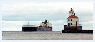
The first stop on our 1999 Fall tour, Wisconsin Point Light sits at the
entrance to Superior Harbor on a pier jutting from the end of a three
mile spit of land, which protects the ore docks and the harbor.
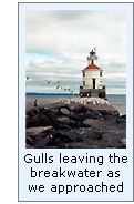 It was a blustery day, so we bundled-up for the walk along the pier. The
walk was somewhat difficult, since most of the pier was comprised of
large chunks of concrete, placed in a seemingly random arrangement, with
only the last 100 feet being cast concrete. As we neared the flat concrete section, increasing numbers of gulls that
had been resting on the pier took wing. With the brisk westerly wind,
they appeared to hover above the pier.
It was a blustery day, so we bundled-up for the walk along the pier. The
walk was somewhat difficult, since most of the pier was comprised of
large chunks of concrete, placed in a seemingly random arrangement, with
only the last 100 feet being cast concrete. As we neared the flat concrete section, increasing numbers of gulls that
had been resting on the pier took wing. With the brisk westerly wind,
they appeared to hover above the pier.
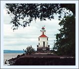
The lighthouse itself is quite attractive, since its' concrete sides and
steel roof are gracefully rounded unlike any others we have seen. Having been
relatively recently painted, the white, red and black color scheme
contrasted beautifully with the grayish-blues of the cool Fall day.
Finding this Light
Taking 53 North toward Superior close to the point at which the divided
highway ends, look for Moccasin Mike Rd. on the right. Turn onto Moccasin
Mike Rd. and follow it around the end of the bay. Wisconsin Point Rd.
will be seen to the left. Turn left on Wisconsin Point Rd. and continue
to the end of the point, approximately 2 miles. From the Northernmost
tip of Wisconsin Point, the view in the photo above left can be seen.
Backtrack approximately 1/3 of a mile, and take the road to the left to
gain access to the pier and the lighthouse itself.
Reference Sources
Inventory of Historic Light Stations,
National Parks Service,
1994.
Annual reports of the Lighthouse Board, various, 1879 – 1909
Annual reports of the Commissioner of Lighthouses, various, 1910
– 1939
Annual reports of the Lake Carrier’s Association, 1903 – 1940
Great Lakes Light Lists, various, 1876 - 1979
Personal visit to Wisconsin Point on
09/05/1999
Photographs from author's personal
collection.
Keeper listings for this light appear courtesy of Great
Lakes Lighthouse Research
|